


National Geographic
5 Viewers
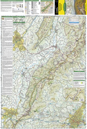
Shenandoah National Park Map
We will deliver your goods as soon as possible
$14.95
Includes hiking and horse trails, the Appalachian Trail, waterfall hikes, wilderness areas and Skyline Drive,Printed on waterproof, tear-resistant material with a plastic coating for exceptional durability,Includes selected waypoints in both lat./lon. and
About this product
The Trails Illustrated Shenandoah National Park map offers clear, detailed coverage of the natural escape that's just 75 miles from the hustle and bustle of Washington, D.C.
Features
- • Includes hiking and horse trails, the Appalachian Trail, waterfall hikes, wilderness areas and Skyline Drive
- • Printed on waterproof, tear-resistant material with a plastic coating for exceptional durability
- • Includes selected waypoints in both lat./lon. and UTM coordinate systems as well as GPS-compatible UTM grid lines for easy navigation
- • Scale of 1:75
- • 000 and 1:37
- • 500
- • National Geographic Maps; copyright 1991; revised 2007
Specifications
| Best Use | Hiking |
|---|---|
| State / Province | West Virginia, Virginia |
| Map Number | 228 |
Often bought with


Shenandoah National Park Map FAQs
Still have unanswered questions and need to get in touch?
Contact usRecipes

Blow-Up Tents Revolutionizing Camping with Effortless Setup and Comfort
Skills
|
Camping Gear

Bivvy Tents The Ultimate Minimalist Shelter for Lightweight Adventures
Skills
|
Camping Gear

Bikepacking Tents The Ultimate Shelter for Lightweight, High-Performance Adventures
Skills
|
Camping Gear


